Enregistrez gratuitement cette image
en 800 pixels pour usage maquette
(click droit, Enregistrer l'image sous...)
|
|
Réf : T01206
Thème :
Terre vue de l'espace - Fleuves - Rivières - Lacs (517 images)
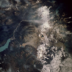
Titre : Katmai National Monument, Alaska, U.S.A. August 1989
Description : (La description de cette image n'existe qu'en anglais)
The second-largest unit of the U.S. National Park System (Yellowstone is the largest), Katmai National Monument and the Valley of Ten Thousand Smokes can be seen in this east-northeast-looking, low-oblique photograph. Located near the northern end of the Alaskan Peninsula, Katmai sits in a presently dormant volcanic region. In 1912, this region was the site of one of the greatest eruptions in recent history. As lava beneath Mount Katmai drained to the west, Novarupta Volcano erupted and then collapsed, forming a huge crater 8 miles (13 kilometers) in circumference and 3700 feet (1129 meters) deep (near the center of the photograph), which formed a lake. The explosion of Novarupta caused 40 square miles (100 square kilometers) of terrain around the volcano to be covered in ash and pumice as deep as 300 feet (90 meters). The Valley of Ten Thousand Smokes to the north-northwest of Novarupta Volcano [72 square miles (187 square kilometers)] had countless holes and cracks (fumeroles) on the surface, through which scalding hot gases (steam) passed to the surface—hence the valley’s name. Today, all but a few of these volcanoes are extinct. Scars or deposits of ash and pumice (grayish-color) from the eruption can still be seen north and south of the water-filled crater. Plants have begun to colonize some portions of the valley. The light blue waters of Naknek Lake can be seen northwest of the Novarupta Crater.
|
|

